Page 1 of 1
Where is map view for GPS tagged photo?
Posted: Fri Aug 11, 2023 4:55 pm
by FKCapitalism2
If i remember correctly there used to be map view for GPS tagged photos, i cannot locate it anymore.
Only thing i find is Metadata > Open GPS location in... menu
Re: Where is map view for GPS tagged photo?
Posted: Sat Aug 12, 2023 8:47 am
by xnview
it's in Info panel
Re: Where is map view for GPS tagged photo?
Posted: Mon Aug 14, 2023 6:51 am
by FKCapitalism2
xnview wrote: Sat Aug 12, 2023 8:47 am
it's in Info panel
Oh in my case i closed info panel completely because never used it.
Re: Where is map view for GPS tagged photo?
Posted: Mon Aug 14, 2023 7:20 am
by michel038
You can also use right click > properties in view mode. This window can be resized...
Re: Where is map view for GPS tagged photo?
Posted: Mon Aug 14, 2023 11:18 am
by FKCapitalism2
michel038 wrote: Mon Aug 14, 2023 7:20 am
You can also use right click > properties in view mode. This window can be resized...
Problem is its for single image only, i want same functionality as in Lightroom/ACDSee where you can see map with images in the folder and can navigate not by thumbnails view, but by map view and open images that i need.
For instance i was walking in the park and taking pictures along the way, i can open map of the park and find the monument then zoom in map and see all the photos that were taken near that monument.
First half of the video shows this functionality
https://www.youtube.com/watch?v=UnSXz0ckFno
Re: Where is map view for GPS tagged photo?
Posted: Wed Aug 16, 2023 2:01 pm
by michel038
I'm using PicaGeoTag freeware
It can read/create/update gpx files (GPS tracks)
It shows photos on a map
You can move or add photos on the map
You can have photos with no GPS coordinates automatically distributed on the map by interpolating the date/time/taken, and update their exif gps data.
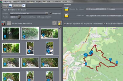
- picageotag.jpg (39.43 KiB) Viewed 12231 times
Re: Where is map view for GPS tagged photo?
Posted: Thu Aug 17, 2023 2:15 pm
by FKCapitalism2
michel038 wrote: Wed Aug 16, 2023 2:01 pm
I'm using PicaGeoTag freeware
It can read/create/update gpx files (GPS tracks)
It shows photos on a map
You can move or add photos on the map
You can have photos with no GPS coordinates automatically distributed on the map by interpolating the date/time/taken, and update their exif gps data.
picageotag.jpg
Would be nice to have this functionality in XNView MP.
Re: Where is map view for GPS tagged photo?
Posted: Fri Aug 18, 2023 6:01 am
by xnview
FKCapitalism2 wrote: Thu Aug 17, 2023 2:15 pm
michel038 wrote: Wed Aug 16, 2023 2:01 pm
I'm using PicaGeoTag freeware
It can read/create/update gpx files (GPS tracks)
It shows photos on a map
You can move or add photos on the map
You can have photos with no GPS coordinates automatically distributed on the map by interpolating the date/time/taken, and update their exif gps data.
picageotag.jpg
Would be nice to have this functionality in XNView MP.
Please make a post in Suggestions